|
|
![]()
|
![]()
|
![]()
|

|
![]()
|
|
Six Nations Land Claim Summaries (Basis & Allegations)
|
![]()
|
|
•
|
![]()
|
Six Nations has been researching Land Claims since the 1970's
|
![]()
|
|
•
|
![]()
|
Of the 29 submitted and potential claims, there are several more to be researched
|
![]()
|
|
•
|
![]()
|
The only claims submitted outside of the Haldimand Tract are Innisfil and East Hawkesbury Townships
|
![]()
|
|
•
|
![]()
|
Specific claims are defined as an unfulfilled Treaty or agreement between Canada and Indians.
|
|
![]()
|
|
![]()
|
![]()
|
![]()
|
|
![]()
|
The Haldimand Treaty of 1784
Whereas His Majesty having been pleased to
direct that in consideration of the early attachment
to his cause manifested by the Mohawk Indians
and of the loss of their settlement which they
thereby sustained - that a ...  View More View More
|
![]()
|
|
![]()
|
![]()
|
![]()
|
|
|
|
![]()
|
![]()
|
![]()
|
|
29. Compensation for Lands included in Letters Patent No. 910 on July 12, 1852, Brantford Town Plot
|
![]()
|
At a Six Nations Council meeting on April 19, 1830, the Superintendent for Six Nations explained the letter of the Lieutenant Governor of Upper Canada regarding Six Nations ceding to the Crown 807 acres for a Town Plot at Brantford. The land was to be divided into lots and sold for Six Nations’ benefit. Three trustees were to take charge of Six Nations’ money. Consequently, on this date, twenty-nine (29) Sachems and Chiefs of Six Nations surrendered (Purported Surrender No. 30) to the King for sale an estimated 807 acres for a Town Plot at Brantford.
On June 29, 1837, John Macaulay, Surveyor General, subdivided the Town Plot of Brantford so each lot might be sold.
On September 15, 1838, Six Nations reported that Sir John Colborne had advised them to surrender to the Government the lands around the Brantford Bridge and he would then compel the squatters to leave their lands. A purported surrender was taken for that purpose, but the squatters still remain on Six Nations lands.
William Walker, Deputy Provincial Surveyor, received instructions from the Surveyor General for the Indian Department, to survey the remaining Town Lots of the Town of Brantford on February 24, 1846.
On April 15, 1852, the Provisional Municipal Council of the County of Brant passed a Resolution requesting information as to what lands, if any, are set apart for County purposes and that a Patent may be issued in their favor.
On April 20, 1852, David Thorburn, Special Commissioner, submits a letter to the Honourable R. Bruce, Superintendent General of Indian Affairs, stating that a block of land in the Town Plot of Brantford was reserved for the purpose of a County Court House.
The Governor General directed on May 4, 1852, that a Patent be issued to County Authorities for a “County Court House” upon payment of the Patent fee.
Subsequently on July 12, 1852, the Crown issued Letters Patent Number 910 to the Council of the County of Brant of the Town of Brantford for 1 6/10 of an acre. These lands were in the original Town Plot of Brantford and consisted of 8 lots for the County Court House. The £2 ($8.00) referred to in Patent No. 910 was the fee for issuing the patent.
ALLEGATIONS
No descriptive plans were signed, witnessed and attached to the Purported Surrender No. 30 in accordance with 1812 Governor's Instructions for the alienation of Indian lands.
In the alternative, Six Nations did not receive full and fair compensation for the lands contained in the Purported Surrender No. 30 as some lands were sold under their appraised value; some lands were not appraised; some lands were obtained by individuals as free grants and no payment whatsoever was made; some lands were taken for public purposes and no payment whatsoever was made; and some lands were obtained on the payment of only a patent fee or administration fee.
Six Nations has never received complete and just compensation for the 8 lots included in Letters Patent No. 910.
|
![]()
|
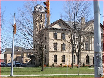
Brantford County Court House
Corner of Market, Wellington, George and Nelson Streets
Part of Letters Patent No. 910
|
![]()
|
**These are brief summaries and they are subject to change as additional research information may be acquired
|
|